


LINCOLN TWP Voting District, Scott County, Iowa
About
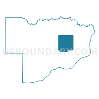
Outline

Summary
| Unique Area Identifier | 583368 |
| Name | LINCOLN TWP Voting District |
| County | Scott County |
| State | Iowa |
| Area (square miles) | 26.63 |
| Land Area (square miles) | 26.63 |
| Water Area (square miles) | 0.00 |
| % of Land Area | 100.00 |
| % of Water Area | 0.00 |
| Latitude of the Internal Point | 41.64592870 |
| Longtitude of the Internal Point | -90.50137170 |
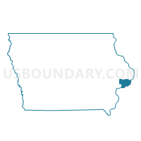
Maps

Graphs
Select a template below for downloading or customizing gragh for LINCOLN TWP Voting District, Scott County, Iowa


Neighbors
Neighoring Voting District (by Name) Neighboring Voting District on the Map
- BETTENDORF W5P2 & PANORAMA PARK, Scott County, IA
- BUTLER TWP Voting District, Scott County, IA
- DAVENPORT PCT 64, Scott County, IA
- ELDRIDGE W/SHERIDAN TWP PART Voting District, Scott County, IA
- LE CLAIRE TWP PART W/O LE CLAIRE Voting District, Scott County, IA
- PRINCETON TWP W/O PRINCETON Voting District, Scott County, IA
- SHERIDAN TWP PART W/O ELDRIDGE Voting District, Scott County, IA
- WINFIELD TWP PART W/O LONG GROVE Voting District, Scott County, IA
Top 10 Neighboring County Subdivision (by Population) Neighboring County Subdivision on the Map
- Davenport city, Scott County, IA (99,685)
- Pleasant Valley township, Scott County, IA (34,936)
- Sheridan township, Scott County, IA (6,213)
- Le Claire township, Scott County, IA (5,335)
- Butler township, Scott County, IA (3,638)
- Winfield township, Scott County, IA (1,693)
- Princeton township, Scott County, IA (1,405)
- Lincoln township, Scott County, IA (553)
Top 10 Neighboring Place (by Population) Neighboring Place on the Map
- Davenport city, IA (99,685)
- Bettendorf city, IA (33,217)
- Eldridge city, IA (5,651)
- Park View CDP, IA (2,389)
Top 10 Neighboring Unified School District (by Population) Neighboring Unified School District on the Map
- Pleasant Valley Community School District, IA (20,868)
- North Scott Community School District, IA (15,203)
Top 10 Neighboring State Legislative District Lower Chamber (by Population) Neighboring State Legislative District Lower Chamber on the Map
- State House District 84, IA (31,647)
- State House District 82, IA (31,123)
- State House District 83, IA (30,728)
- State House District 81, IA (30,091)
Top 10 Neighboring State Legislative District Upper Chamber (by Population) Neighboring State Legislative District Upper Chamber on the Map
Top 10 Neighboring 111th Congressional District (by Population) Neighboring 111th Congressional District on the Map
Top 10 Neighboring Census Tract (by Population) Neighboring Census Tract on the Map
- Census Tract 102.02, Scott County, IA (5,860)
- Census Tract 102.01, Scott County, IA (5,742)
- Census Tract 101.01, Scott County, IA (3,701)